May 16/17 - Grand Staircase Ecalante National Monument
Sat, May 16 – It was later than planned when we finally got moving.
The plan for the day was to go to Escalante, the biggest town from here to
The fee for entrance to the forest was $6, more than we really could spend today. We talked to the ranger and he gave us some great ideas on what to see in the next few days. Tyne thought he was from
Thanking the ranger for his advice, he headed into the vistor center and we eyed the lake. It had been since Vegas since we had a shower, and we hadn't been to many bodies of water since then either.
Escalante turned out to be tiny; two gas stations, one grocery store and a couple hotels and gift shops. This town was among the last in the country to get reliable mail service. Even less than 100 years ago, milk and mail were brought in via the single mule that made the trip. Most of the mail had milk stains and most of the milk had turned to cream or butter, but it was the only option the townspeople had. We didn't have much luck wit our errands. We did find wi-fi, and stopped at the grocery store. Just crackers, white rice and tortillas costs us nearly 8 bucks.
We almost stopped at the visitor center to get maps, water, and a backcountry permit in case we ended up staying a night in the bush.
After a couple of failed attempts at getting to a good hike, we settled on Phipps arch, which the guide paper said was about 5 miles round trip. Parking at the crowded
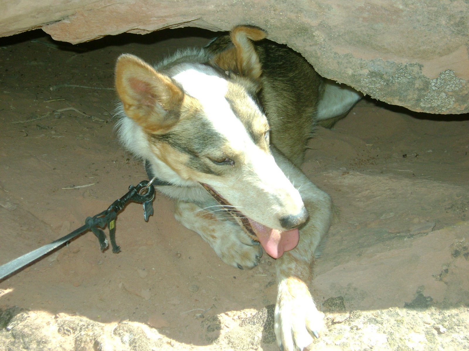
The trail followed the river, and once even had a ladder to climb to get over rocks that blocked a narrow pass to the river. Within a mile, we had come to our first river crossing. The water was almost a foot deep in places, but it felt great after hiking in the sun. Dazey enjoyed the dip as well and we continued down the canyon.
On the left we heard running water, but nothing appeared around the bend. Then we realized that the water was running underneath the canyon wall and coming into the river below us.
The trail was not marked, and there technically wasn't a trail from the river up the side canyon to the arch, but many people had come through and a herd trail was easy enough to spot and follow. When we reached the side canyon we knew it because most of the tracks headed upstream.
Walking up the wash a ways, we came to a smaller canyon on the right with tracks leading into it. Taking the trail, we soon passed a lone women who said the natural bridge was just around the corner. We found something, even if it was something we were't looking for. The
Back to the main canyon, we continue upstream looking for this arch. The guidebook says its up a canyon on the left, then you have to rock scramble to get there. We see a dead trail layed up against the small opening to a canyon and we carefully climb up it. A half mile up this canyon, it's a dead end. Luckily, I had a geocache programmed in my GPS that was just 50 feet from the arch, so after a check there, I knew the arch was 800 feet to the south in the next canyon.
Getting kind of tired now, we drink some more water and try this last canyon. After a good walk in, it dead ends as well. Looking at the GPS, I saw that we circled the arch, and it had to be "up there" high on the canyon walls.
Dazey was getting really hot, so we rested for 10 minutes under a juniper tree before scaling another rocky hillside. It took almost half an hour to climb this last bit, and soon Phipp's arch appeared before us. It was huge, nearly 100 feet wide and 40 high, and as it was so hidden and far out here, we were really impressed. We ate a life giving orange, and headed back to the trail.
We were going to go on a second hike, walk in a few miles and camp on Sandy creek, but by the time we made it back to the car it was after 6pm. We drove down a few miles to Calf creek campground but it was totally full. The camp host suggested we drive 5 miles back into town, cross the cattle guard, hang a left and across another cattle guard. This would be BLM land, free to camp on and boasted some incredible views.
30 minutes later we were happy that we didn't stay at the crowded Calf Creek. This spot was pretty touch to drive up to, but with my skilled driving we were out and looking at the views in no time. We could even see the rock formations where Phipps arch was and the canyon that we walked up along
We made white rice with refried beans, and mixed in some Vienna Sausages to try to finish them up. (Vienna Sausages mysteriously appear, we somehow had three cans of them and neither of us had ever bought a can.) As the sun set, we found a tree that had some of the biggest and best amber ive ever seen on it. We collected some and sat out in the cool air as the stars appeared.
I had my little tent set up in a sand dune not far from the car and
Sun, May 17– The sun woke me at 630 am, but after 20 minutes it was high enough to be blocked by the little juniper I was under. By 8am though, it had gotten too hot to bear so I got up and took apart my tent. I cleaned up the site, made a cup of coffee, and tried to wake
"I slept like crap," she said, "Let me have 15 more minutes."
An hour later, I was sitting against a tree in the shade reading and
Our destination for the day was
We passed by ancient granaries that were used 800 years again by Indians storing their grains, and also spotted some pictographs on the wall of the canyon on the far side. Finally we reached the cool and shaded waterfall oasis. We waded into the water and slashed it on our faces. Dazey drank all she could while
Starting back, we found a cache a few hundred yards downstream from the waterfall, not far from the trail but high up the side of the canyon, all the way to the vertical west wall. The view of the waterfall was great, a view that most people don't even know is possible. Dazey and I ran down the slope, "surfing" on loose gravel and jumping back onto the trail just as two foreign tourists hiked around the corner. They looked pretty surprised to see us appear from a steep embankment.
The sun beat down on us pretty badly on the way back and Dazey was really starting to feel it. She would go from shady spot to shady spot, and eventually just sat down under a pinion pine and refused to budge. Even with lots of cool water, she took awhile before she was able to continue. I carried her over my shoulders for a while and she liked that, but after 100 feet she jumped down when she spotted a lizard in the bush. When we reached the creek again, I pushed Dazey in and to her annoyance, splashed her until she was soaked. I think she was a little mad at first but she quickly regained the energy she needed to get back to the Nar.
The Escalante area and Grand Staircase had treated us well. Driving north towards
Just as we came into
Continuing another eleven miles down the scenic road, we came to the slot canyon. It was pretty short, but instead of a dusty, hot and little vegetated landscape, we walked into a very narrow canyon that was filled with tall shade trees and had an "other worldly" vibe. The ground was cool, soft sand and there wasn't anything sharp, unpleasant or ugly. This little haven was amazing. We looked forward to
We had intended on stopping at a grocery stop to buy an artichoke and some other food, but
It was getting late in the afternoon, so we made plans to camp in Dixie Forest Again. Driving into the mountains north, we drove into birch forest high on the mountain. The pass was 9600 feet, the highest we had driven at so far in the trip. After the pass there were a lot of turnoffs to good camping areas, but the roads on them were all torn up. We had to turn around a few times, but finally we found a good spot while pulling over to look at a view. It was a slow drive in and out because it was pretty rough, but we had a large camping area all to ourselves.
We made a small fire, keeping it very small because of the gusting winds and abundance of dry pine needles.
Hotmail® has ever-growing storage! Don't worry about storage limits. Check it out.
posted by freeagentjay @ 4:13 PM
0 Comments
![]()

0 Comments:
Post a Comment
<< Home